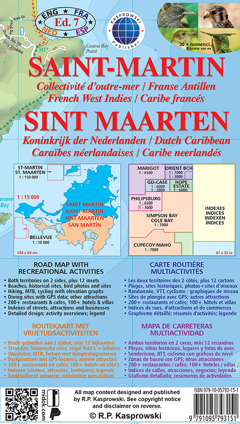
Saint-Martin
Collectivité d'outre-mer / Franse Antillen
French West Indies / Caribe francés
Sint Maarten
Koninkrijk der Nederlanden / Dutch Caribbean
Caraïbes néerlandaises / Caribe neerlandés
[1 : 15 000] Ed. 7
LARGE MAP, designed for easy opening and refolding. Sold folded in pocket format 5 1/8" x 8 3/4" (13 cm x 22 cm). In full it measures 41 x 35 in. (104 x 89 cm).
EXTENSIVE MAP KEY provides all information in four languages: ENGLISH, FRENCH, DUTCH, SPANISH
MAP FEATURES :
-
Full-color layout with rich topographic detail, symbol key and distance scales;
-
Depth curves, soundings in meters, longitude and latitude lines and other identifiers;
-
Map key provides all features in 4 languages: English, French, Dutch, and Spanish;
-
Both FRENCH AND DUTCH TERRITORIES (incl. Tintamarre Island) [1 : 15 000] on 2 sides with a total of 12 insets :
-
PHILIPSBURG [1 : 6500] with inset [1 : 3000] (Dutch capital),
-
SIMPSON BAY - COLE BAY [1 : 7000] (large inset),
-
CUPECOY - MAHO [1 : 7000] (large inset),
-
MARIGOT [1 6500] (French capital),
-
ORIENT BEACH [1 : 7000] with inset [1 : 3000],
-
GRAND-CASE [1 : 6000] with inset [1 : 3000],
-
HOPE ESTATE [1 : 6000],
-
BELLEVUE with mountain biking trails [1 : 10 000],
-
ST. MARTIN THUMBNAIL with numbered beach, diving, and birding sites [1 : 150 000].
-
INDEXES OF :
-
major attractions,
-
streets and roads,
-
restaurants,
-
hotels,
-
beaches,
-
diving locations,
-
birding areas,
-
historical sites.
-
Beaches (incl. nude beaches) and natural pools with snorkeling sites, kayaking trails and other water and outdoor sports;
-
Diving and shipwreck sites with depths, GPS locations, and sea life to be found;
-
Hiking, mountain biking, and cycling routes with detailed elevation graphs, difficulty gradient, incline %, total ascent/descent, GPS data (MTB trails);
-
Bird-watching areas with GPS data, 20 large bird photos, and official nomenclature;
-
Casinos, hotels, restaurants, supermarkets, pharmacies, hospitals, banks, post offices and other services;
-
Sugar mills, forts, plantations, museums, places of worship and other historical sites;
-
Scenic views, natural reserves, reefs, sea turtle nesting sites, melocactus fields, and other natural attractions.
ROAD MAP WITH RECREATIONAL ACTIVITIES (ENGLISH)
- Both territories on 2 sides, plus 12 insets
- Beaches, historical sites, bird photos and sites
- Hiking, MTB, cycling with elevation graphs
- Diving sites with GPS data; other attractions
- 200+ restaurants & cafes, 100+ hotels & villas
- Indexes of streets, attractions, and businesses
- Detailed design; activity overviews; legend
ROUTEKAART MET VRIJETIJDSACTIVITEITEN (NEDERLANDS)
- Beide gebieden aan 2 zijden, plus 12 bijkaarten
- Stranden, historische sites, vogel foto's en lokaties
- Wandelen, MTB, fietsen met hoogtediagrammen
- Duikplaatsen met GPS-locaties; andere attracties
- 200+ restaurants en cafés; 100+ hotels en villa's
- Indexen (straten, attracties, bedrijven); legende
- Gedetailleerd ontwerp; activiteiten overzichten
CARTE ROUTIÈRE MULTIACTIVITÉS (FRANÇAIS)
- Les deux territoires des 2 côtés, plus 12 cartons
- Plages, sites historiques, photos et sites d’oiseaux
- Randonnée, VTT, cyclisme avec graphiques de niveau
- Sites de plongée avec GPS; autres attractions
- 200+ restaurants et cafés; 100+ hôtels et villas
- Indices de rues, d'attractions et de commerces
- Graphisme détaillé; résumés d'activités; légende
MAPA DE CARRETERAS MULTIACTIVIDAD (ESPAÑOL)
- Ambos territorios en 2 caras, más 12 recuadros
- Playas, sitios históricos, lugares y fotos de aves
- Senderismo, BTT, ciclismo con gráficos de nivel
- Zonas de buceo con GPS; otras atracciones
- 200+ restaurantes y cafés; 100+ hoteles y villas
- Índices de calles, atracciones y negocios; leyenda
- Grafismo detallado; resúmenes de actividades